


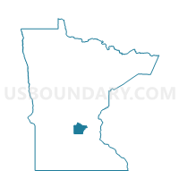
Albion Twp. Voting District, Wright County, Minnesota
About
Outline

Summary
| Unique Area Identifier | 604960 |
| Name | Albion Twp. Voting District |
| County | Wright County |
| State | Minnesota |
| Area (square miles) | 35.48 |
| Land Area (square miles) | 32.66 |
| Water Area (square miles) | 2.82 |
| % of Land Area | 92.06 |
| % of Water Area | 7.94 |
| Latitude of the Internal Point | 45.19349360 |
| Longtitude of the Internal Point | -94.07879670 |
Maps


Graphs
Select a template below for downloading or customizing gragh for Albion Twp. Voting District, Wright County, Minnesota


Neighbors
Neighoring Voting District (by Name) Neighboring Voting District on the Map
- Chatham Twp. Voting District, Wright County, MN
- Cokato Twp. Voting District, Wright County, MN
- Corinna Twp. Voting District, Wright County, MN
- French Lake Twp. Voting District, Wright County, MN
- Maple Lake Voting District, Wright County, MN
- Maple Lake Twp. Voting District, Wright County, MN
- Marysville Twp. Voting District, Wright County, MN
- Middleville Twp. Voting District, Wright County, MN
Top 10 Neighboring County Subdivision (by Population) Neighboring County Subdivision on the Map
- Corinna township, Wright County, MN (2,322)
- Marysville township, Wright County, MN (2,147)
- Maple Lake city, Wright County, MN (2,059)
- Maple Lake township, Wright County, MN (2,048)
- Cokato township, Wright County, MN (1,311)
- Chatham township, Wright County, MN (1,302)
- Albion township, Wright County, MN (1,255)
- French Lake township, Wright County, MN (1,172)
- Middleville township, Wright County, MN (937)
Top 10 Neighboring Place (by Population) Neighboring Place on the Map
Top 10 Neighboring Unified School District (by Population) Neighboring Unified School District on the Map
- Annandale Public School District, MN (10,429)
- Dassel-Cokato Public School District, MN (10,084)
- Howard Lake-Waverly-Winsted Public School District, MN (8,757)
- Maple Lake Public School District, MN (4,935)
Top 10 Neighboring State Legislative District Lower Chamber (by Population) Neighboring State Legislative District Lower Chamber on the Map
Top 10 Neighboring State Legislative District Upper Chamber (by Population) Neighboring State Legislative District Upper Chamber on the Map
Top 10 Neighboring 111th Congressional District (by Population) Neighboring 111th Congressional District on the Map
Top 10 Neighboring Census Tract (by Population) Neighboring Census Tract on the Map
- Census Tract 1007.03, Wright County, MN (8,470)
- Census Tract 1011, Wright County, MN (7,416)
- Census Tract 1004, Wright County, MN (5,024)
- Census Tract 1013, Wright County, MN (4,964)
- Census Tract 1005, Wright County, MN (4,675)
- Census Tract 1012, Wright County, MN (3,931)